Fool’s Gold
By Steve Watkins
Years ago, I took my daughter Maggie to India. She was 14 at the time, and we found ourselves early one morning wrapped in blankets and drinking chai on the balcony of a small hillside hotel overlooking a wide bend in the upper reaches of the Ganges. We were near the village of Lakshman Jhula, just north of Rishikesh in the mountain state of Uttarakhand. The valley below us was thick with rising fog, but as the clouds slowly lifted we saw white-clad figures making their way down to the rocks and sand on a wide point bar at the river’s edge. Maggie said she thought it looked like the perfect place for meditation. We held onto that thought for a while, sitting and watching and listening in silence, until I pointed out that the people we saw weren’t drawn to the Ganges for contemplation and prayer. They were seeking secluded spots so they could drop their drawers, squat, and take their morning shits. It was the place where villagers had been doing their business for a hundred years, likely much longer—flushed periodically when the river rose high enough from the snow melts in the Himalayas to wash it clean.
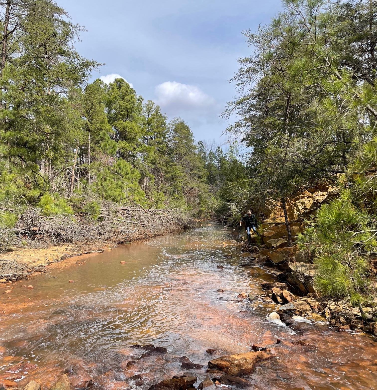
I thought about that recently when I showed one of my younger daughters, Claire, a photo I’d taken of Contrary Creek in nearby Louisa County, Virginia—a tributary that for most of its 8-kilometer run is red, both the water and the scrub-pine-topped banks on either side: a little lighter, a little coppery at times when it’s dry, a deeper, scarier red or orange after it rains. Claire said it looked beautiful, and I couldn’t say she was wrong.
Contrary Creek March 2024/Steve Watkins
My pal Amy and I had been similarly taken by the strange beauty of Contrary Creek when we climbed down the steep, degraded bank from the U.S. 522 bridge earlier this year. The red current was running fairly high as we waded upstream perhaps a quarter of a mile in the highly acidic, highly toxic stream—looking for but not finding remnants of a landscape art installation made of limestone that had been erected a dozen years before, and then deliberately destroyed and left to wash away, or preferably erode, over time. We weren’t the only ones drawn to Contrary Creek that day, though we were the only ones actually in it. Right after we arrived, a couple pulled their truck off the road for a little quasi-clandestine canoodling. They were still there an hour later when we made our way back out to the road and drove off to the nearby town of Mineral, population 500, for lunch at the Mineral Restaurant, a “quint [sic] dive diner,” as one Yelper described it. “No credit cards. Cash or local checks only.”
The official name for U.S. 522 on its 160-mile journey through Virginia is Zachary Taylor Highway, named after the 12th president, “Old Rough and Ready” as he was popularly known: Mexican-American War and Second Seminole War general, plantation owner, enslaver, reluctant father-in-law of Jefferson Davis, union preserver of sorts. Born in nearby Orange County, Taylor died during his second term in office, probably from acute gastroenteritis after eating and drinking an excessive amount of iced milk and cherries, though it’s unlikely the treatment did him much good, either: heavy doses of ipecac, mercury, opium, and quinine. Either that or, as some still speculate, he was assassinated, possibly by his son-in-law, the future president of the Confederate States of America, though exhumation of Taylor’s body in 1980 and tests for lethal pathogens, specifically arsenic, were inconclusive.
***
Contrary Creek has been running red ever since the early 1800s discovery of the so-called gold-pyrite belt, a 140-mile-long vein that runs underground through the mineral-rich heart of Virginia, from Fairfax County at one end to Buckingham County at the other. Dead center—well, dead in the sense that nothing lives there and hasn’t for probably 200 years—is Contrary Creek, what an environmental scientist friend who’s been studying it for the past decade calls a “focused strip of contamination” because it’s been carrying toxic acid drainage for all that time from the iron and pyrite and gold mines that once crowded its banks.
How red is Contrary Creek? So red you can see it from outer space, sort of—in satellite imagery on Google Maps, anyway, from where the creek starts on private property just north of Mineral, then as it flows northeast for a few kilometers until taking a hard right turn under the Highway 522 bridge. The abrupt change in direction is possibly what gave the creek its name. (Locals sometimes call it Stinky Creek instead because of the sulfur smell.) Landscape architect and filmmaker Asa Eslocker, who constructed a limestone spiral jetty and obelisk in Contrary Creek back in 2012, says he’s “90 to 95 percent sure” the direction change is the reason—though a longtime resident Amy and I met at the Mineral Diner was just as firm in her belief that the creek got its name because the acid drainage from the old pyrite mines rendered it “contrary to what ought to be able to grow there, but can’t.”
Or, as our environmental scientist friend Melanie Szulczewski more succinctly put it: “Contrary to life.”
After making that hard-right turn at the Highway 522 bridge, the creek runs due east for a few more kilometers, flowing, or at times trickling, between steep banks under more scrub pines until it enters one of the dozens of coves that make up the 200 miles of shoreline for Lake Anna, a 13,000-acre reservoir that hosts, and cools, a couple of reactors at the North Anna Nuclear Generating Station. Lake Anna, an “impoundment” of the once free-flowing North Anna River, is a Frankenstein’s monster, engineered into artificial existence 50 years ago on land taken through eminent domain from African American farm families. Dug up and eventually flooded—in part by heavy rains from 1972’s Hurricane Agnes—it’s now a recreational destination with a state park, half-million-dollar second homes, retirement villas, marinas, recurring hydrilla infestations, grass carp introduced to control, i.e. eat, the hydrilla (and herbicides to finish off the job), massive toxic algal blooms from excess fertilizer and storm water runoff, and a system of underwater pipes that constantly cycle in cold water from the public side of the reservoir to the reactor side for nuclear boiling. Fish get cycled in, too, or what’s left of them after they’re sucked through filters and ground into fish parts. Word is the fishing’s better on the warm side of the lake—giant largemouth, striped, and hybrid striped bass, monster black crappies—because all those bass and crappies get fat and lazy from their steady diet of chum.
(As I write this, reports have been coming in about dozens of people, most of them children, who contracted E. coli after swimming in Lake Anna over the Memorial Day weekend. A number have been hospitalized for treatment of severe gastrointestinal issues—stomach cramps, diarrhea, vomiting, fever, chills, and worse. One parent reported that her 2-year-old who played in the water there went into kidney failure and is now on dialysis.)
Nobody lives on Contrary Creek for most of its run through Louisa County, and the handful of homeowners in the cove where it spills into Lake Anna keep their boats dry-docked so the hulls don’t rust out and corrode from the high acid level of the tributary. The Virginia Department of Environmental Quality called Contrary Creek “arguably the worst acid mine drainage site in Virginia.” And the North Anna River was long considered the most polluted waterway in the commonwealth below the confluence with the creek before both the river and the confluence were subsumed by the reservoir.
***
The environmental degradation of Contrary Creek got its start in the 1830s and continued in earnest for most of the next hundred years as first its iron ore deposits and later its pyrite were in high demand. Pyrite, a mineral dubbed fool’s gold because of its resemblance to the real thing, is a common source for sulfuric acid, an essential ingredient in fertilizer, gunpowder, dyes, glue, automobile batteries, you name it. At one time, nearly 40 percent of America’s pyrite came from Virginia, and most of that from the mines in Louisa County. While there were several gold mines in the area as well, they were never very productive. Pyrite, though, was another story, eventually becoming such a big deal that in 1902 the town dumped its original name, Tolersville, and changed it to the Mineral it still is today.
The boom only lasted about 20 years, until the end of WWI, when new and cheaper chemical deposits and processes elsewhere were discovered for producing sulfuric acid. By 1920, the mines were all closed, though the owners left behind enough exposed pyrite and other toxic minerals to contaminate Contrary Creek in perpetuity.
The science isn’t complicated: The Contrary Creek bed and banks and water are a slimy red because of all the iron that leaches from the “overburden” left over from the mining days, some from still-open holding ponds and mine shafts, the rest from giant piles of mineral waste—called tailings or culm. The exposed pyrite oxidizes in water and air and becomes sulfuric acid, which drains into the stream from multiple runoff sites, especially when it rains, keeping the pH at such a low level that nothing can survive. A few water bugs, maybe. A little algae. Szulczewski, the environmental scientist, says she saw a fish there once, but it was dead.
Back in the 1970s, the Environmental Protection Agency came up with the idea of dumping truckloads loose stone or riprap along the stream and on the banks to prevent erosion and the continuing “availability” of contaminants from the abandoned mines. They capped some of the open mine shafts, leveled some of the tailings, dumped in limestone to help neutralize the acid runoff, covered culm piles, even planted grasses and trees. And, to top things off, they hauled in tons and tons of “wastewater sludge” from D.C.—processed shit—to serve as a “soil conditioner.” But none of it worked for very long, if ever, though the weeping lovegrass did show promise for awhile.
It would take millions of dollars, and years of work, to resuscitate Contrary Creek at this point. No one actually knows how much or how long.
The only living creatures you’ll find in Contrary Creek these days are prospectors, hundreds if not thousands every year judging from the cascade of mentions and videos on gold-fever websites and discussion boards—whole families from all over who couldn’t care less about the sad fact that nothing, plant or animal, can live in the red-running stream. They’re just there for the gold, such as it is. Not that they have much success, even with all the sophisticated prospecting equipment they bring along with them, as a veteran miner, Dirtman, explains in this video. Most end up spending more money replacing their acid-eaten clothes than they might make from the few specks of gold (or mica, or quartz, or pyrite) that happens to find its way into their prospecting pans.
***
“Contrary Creek is a heavily polluted, acidic stream that flows through a post-industrial mining wasteland in central Virginia.” That’s how Asa Eslocker, the landscape architect, begins the narrative for his August 2012 public art installation Contrary Remediation: The Contrary Creek Design-Build-Destroy Project. I stumbled across the account last year while researching something else, and got in touch with Eslocker, who works in urban planning these days with the Charlottesville-based Renaissance Planning Group. He’s the kind of person who on his honeymoon goes to Ghana to paint sidewalks, and who in his company bio describes himself as “Proud Dad/Husband, FAA Certified Drone Pilot, E-bike enthusiast, Jedi-in-training.”
Eslocker’s Contrary Creek installation project came on the heels of an emotional pilgrimage through coal country he’d made in spring 2012, a 1,300-mile road trip to research and document toxic landscapes, acid mine drainage, and coal mining reclamation—“related themes of my family’s history in mining, cultural identity, and the ecology and science of toxic site remediation,” as he wrote me later. The trip ended near the Ohio River where Eslocker met up with his father to visit the coal mine site—and later the grave—where his great-grandfather had been killed in a Meigs County, Ohio, mine collapse back in 1928.
I followed up our talk with deep dives into the science and history of gold and pyrite mining in Virginia, side trips into the construction and hydrology and ecology of Lake Anna, and consultations with Szulczewski about soil science and environmental toxicology—all of which eventually led to Amy and me wading up Contrary Creek that warm winter day not long ago in our goloshes, as James Joyce spelled it in his short story “The Dead,” and which one of his characters, Gretta Conroy, calls “guttapercha things.”
We were struck by all the red, of course—the steep rocky bank, the riffled creek bed, the water itself—and the odd floating clouds of foam. Dirtman had mentioned a couple of species of fish and crawfish that he says have somehow adapted to the acidic conditions, but we saw no evidence of them while we were there, and nobody we talked to has either. We saw no wildlife on the banks. No birds in the trees. No insects. Nothing living besides us, a couple of bumbling interlopers, and the skinny pines on the banks above.
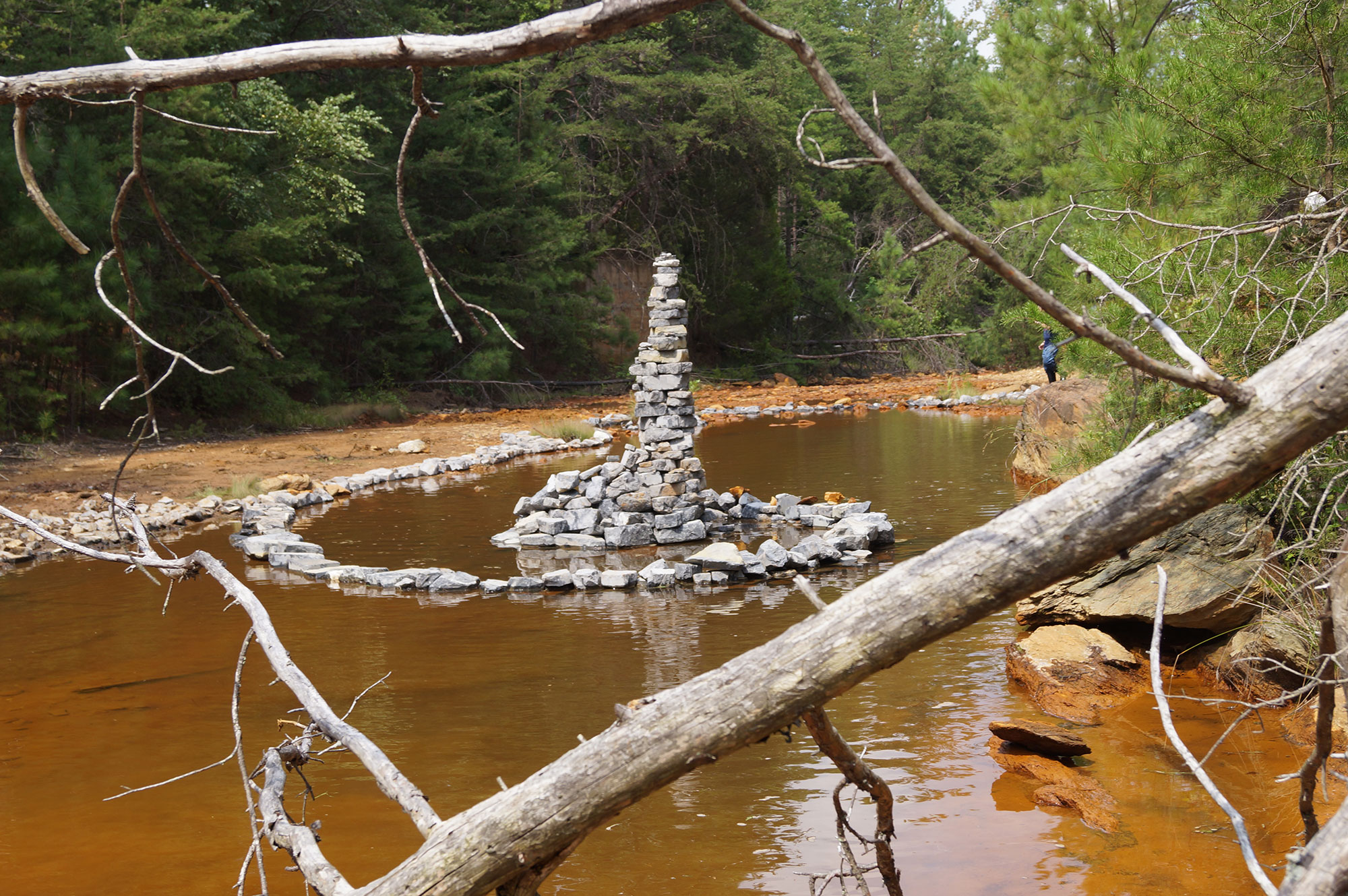
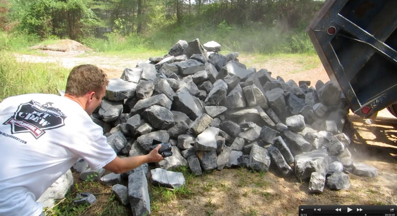
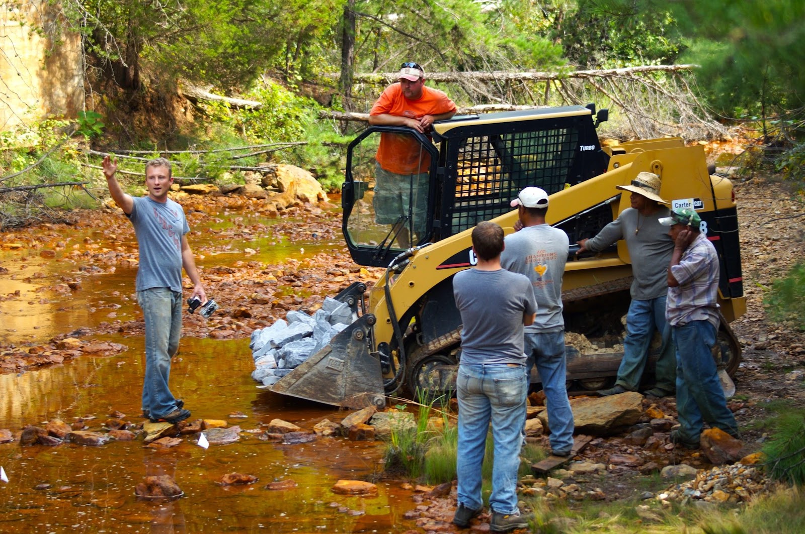
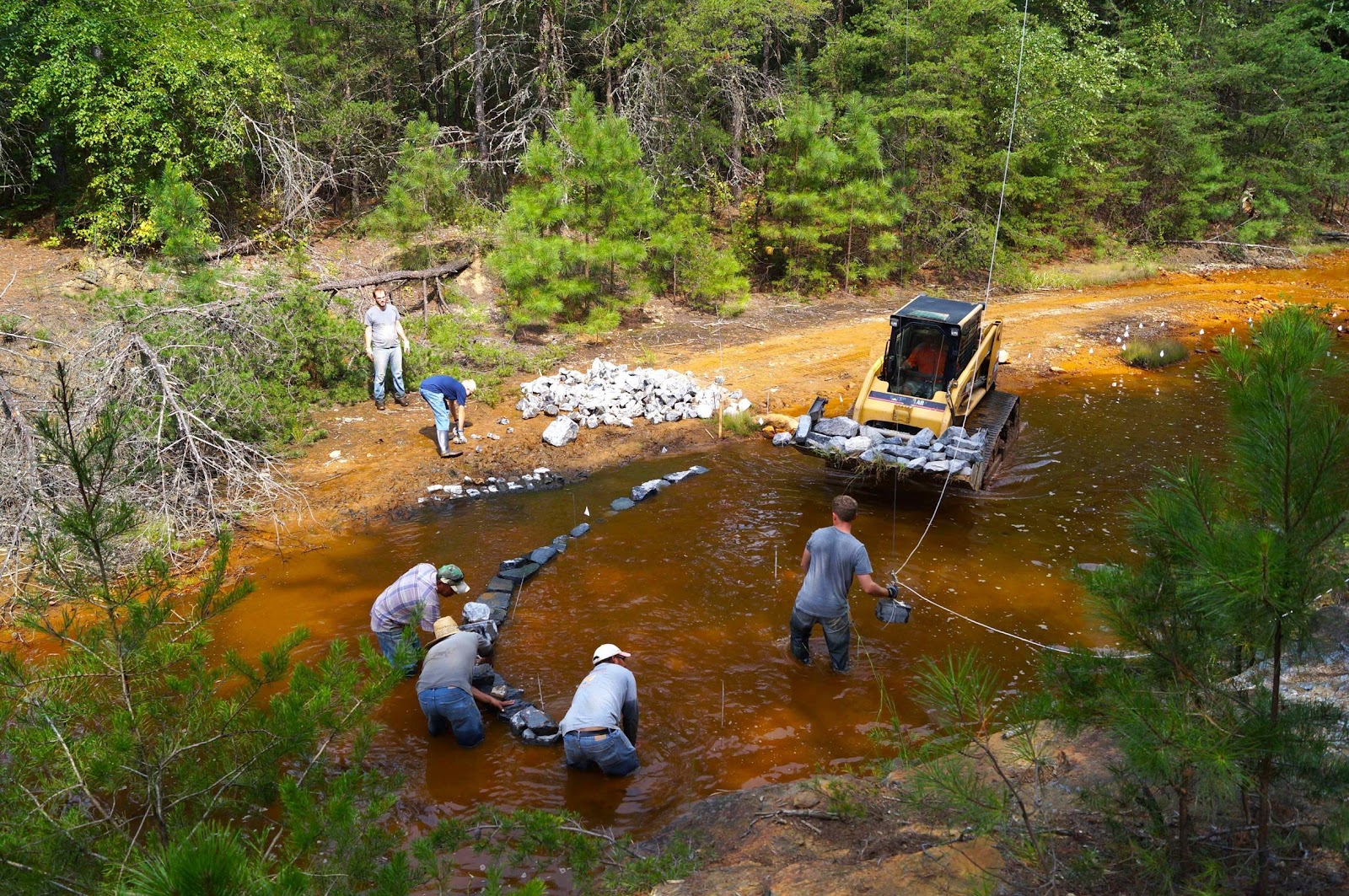
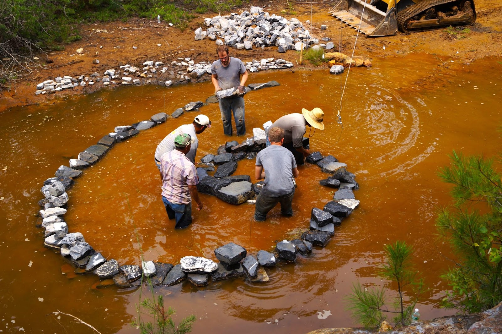
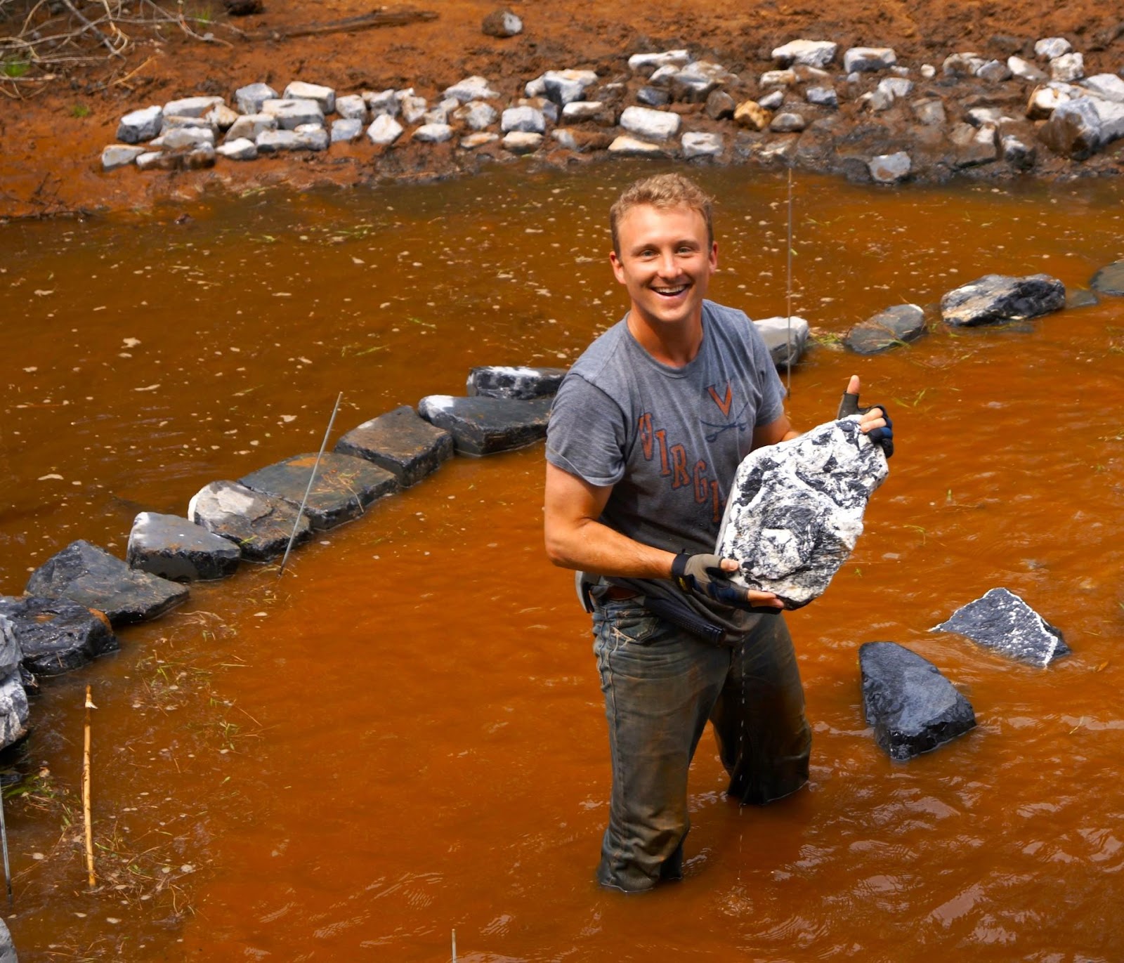
The winter creek was running a little higher the day we were there, but I expect it was much the same otherwise as it had been a dozen years before when Eslocker, just finishing his master’s degree at the University of Virginia, first learned about the creek from one of his advisers, and visited it himself, and came up with the idea for his project. After landing a $5,000 4VA arts grant, and inspired by Robert Smithson’s 1970 black basalt Spiral Jetty installation in the Great Salt Lake, Eslocker bought 15 tons of limestone from a quarry near Harrisonburg, Virginia, and had it trucked over to a drop site down a dirt access road near the Highway 522 bridge. With a team of volunteers and paid workers, he then bent to the task of constructing a meandering pathway along the creek edge, leading to his own spiral jetty in the middle of the stream, at the center of which he built a 10-foot stacked-limestone tower which he intended to knock down—and did—the next day, August 25, 2012.
Like Buddhist monks with their colored sand mandalas. Banksy and his self-shredding painting. Only Eslocker had a different purpose in mind.
Thirty-five friends and Mineral townspeople showed up for the ceremony, with bluegrass banjo, beer, barbecue, and small limestones coated with “VOC free, highly alkaline blue pit lime paint” for folks to throw into the orange creek for good luck. At the appointed hour, from a perch at the top of one of the steep Contrary Creek banks, Eslocker, with help from the Mineral mayor, swung a 50-pound “wrecking stone” into the obelisk, toppling all the limestone rocks into the stream in an act he described as “similar to a christening of a seafaring vessel.” Eslocker, who in an earlier life had won a couple of Emmys as an investigative reporter and producer for ABC News, made sure to film the event, which you can watch if you scroll to the bottom of the page here. (Or, if you’d like to see a longer version—in 3D of all things—you can check that out here.)
***
One year earlier, on Aug. 23, 2011, Mineral had been at the epicenter of a 5.8 magnitude earthquake that shook much of the East Coast all the way up into Canada and as far west as Illinois—the most widely felt earthquake in U.S. history. It was a source of some pride in Louisa County, but also, with 450 recorded aftershocks in Mineral, a source of some lingering nervousness as well. People jumped every time a passing train rattled their windows. All the Louisa County schools were damaged—two had to be rebuilt—and kids attended classes in trailers for quite awhile. But the nearby North Anna Nuclear Generating Station held, with no cracks or accidental release of radiation from the reactors as far as anybody knows. The current in Lake Anna still flows backward in places, as it was engineered to do. The hydrilla still proliferate at times, choking off oxygen in the lower depths of the impoundment. The algal blooms continue their annual toxic invasions, while the nuclear side, walled off by a series of earthen dikes, keeps cooking its piped-in water 14 degrees warmer than the rest of the reservoir. And now the E. coli.
The good news about Contrary Creek is that hydrilla, algal blooms, E. coli—none of those stand a chance there because of the free-running current and the acid drainage. The bad news, of course, is that nothing else stands a chance there, either.
There were no aftershocks from destruction of the stone obelisk in Contrary Creek a year after the earthquake. The water was running so low that day that it didn’t even make much of a splash. There was just the moment with the wrecking stone, the christening, and then, after everybody went home, the slow, imperceptible erosion over time of 15 tons of blue piedmont limestone left in the current to neutralize acid mine drainage so the water might flow clean again—a little bit, and for a little while: a small, symbolic act of environmental remediation for a contaminated creek that’s run toxic and red for much of the past 200 years, and most likely always will, at least in human time, still contrary to life.
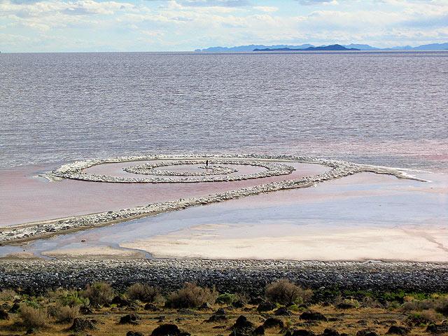
Robert Smithson’s Spiral Jetty, Great Salt Lake, Utah, 1970
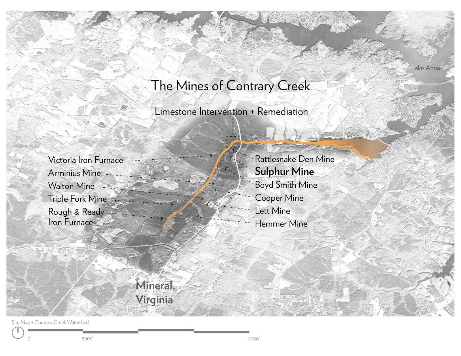
The Mines of Contrary Creek/Asa Eslocker
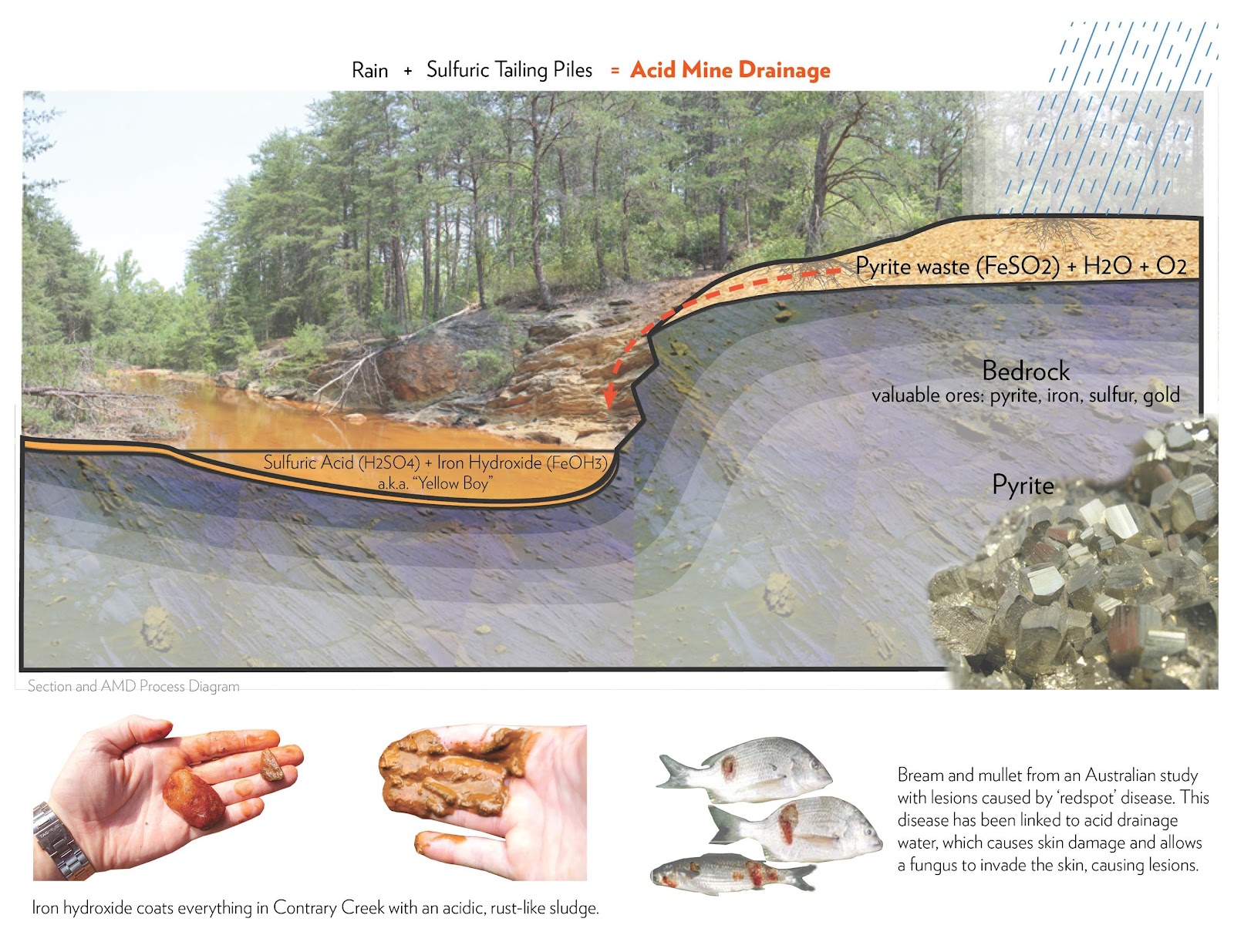
Graphic of acid mine drainage contamination on Contrary Creek/Asa Eslocker
15 tons of limestone
Beginning construction
Construction of spiral jetty
Completion of spiral jetty
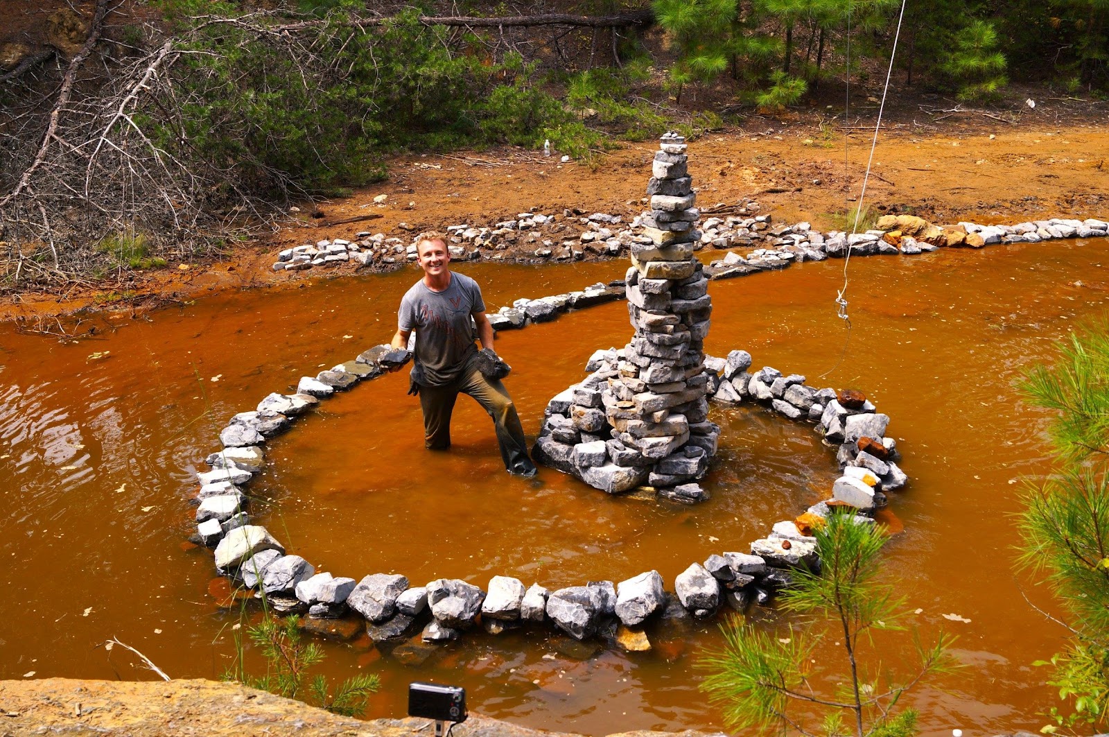
Limestone obelisk sculpture at center of spiral jetty
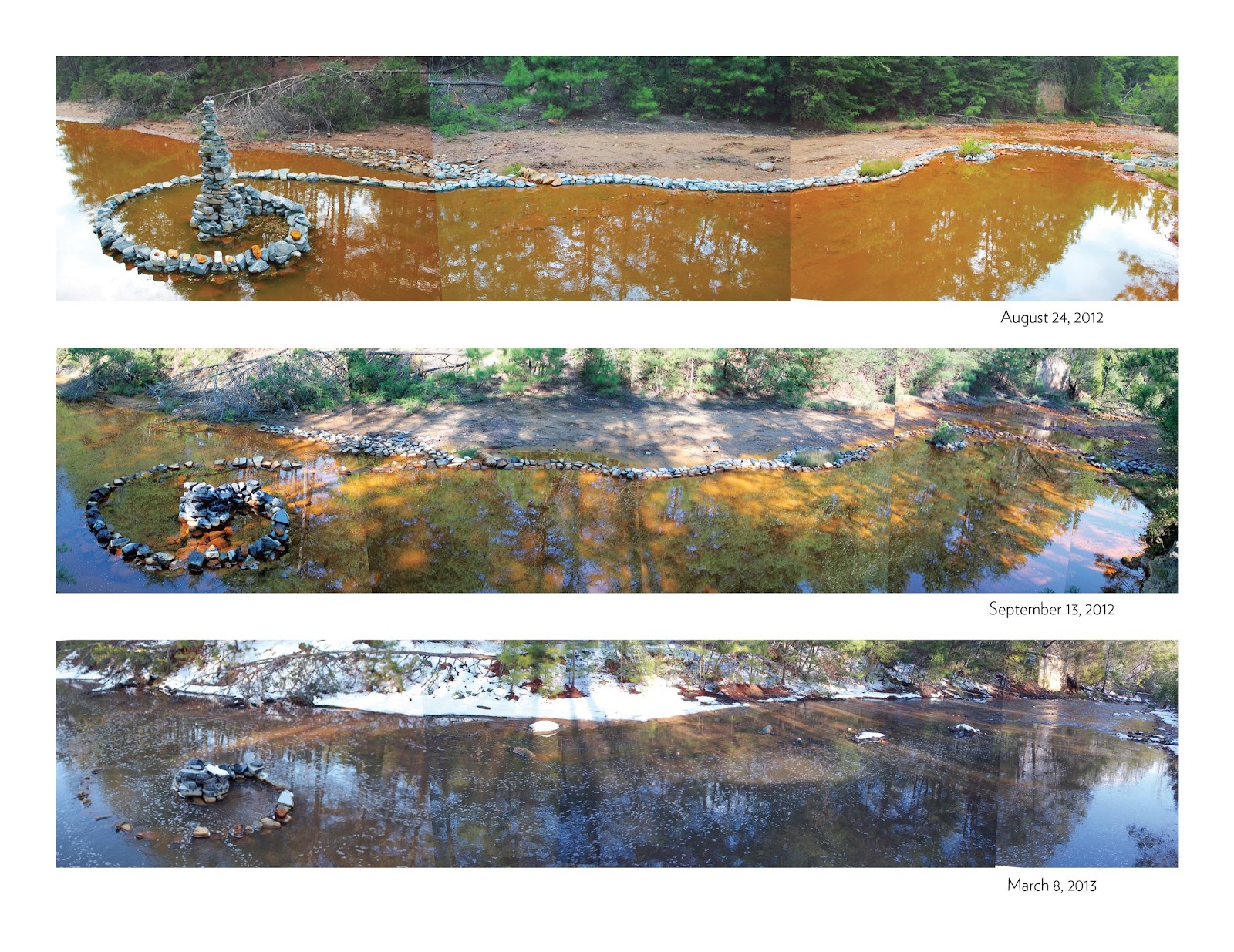
Changes to Contrary Creek over six months—August 2012, September 2012, March 2013/Asa Eslocker
Asa Eslocker at Contrary Creek, August 24, 2012
***
Steve Watkins is co-founder and editor of PIE & CHAI, a professor emeritus of English, a longtime tree steward with Tree Fredericksburg, an inveterate dog walker, a recovering yoga teacher and co-founder of two yoga businesses, father of four daughters, grandfather of four grandsons, and author of 15 books. His author website is http://www.stevewatkinsbooks.com/.